Sites & Buildings
Nutrien Crossroads Mega Site
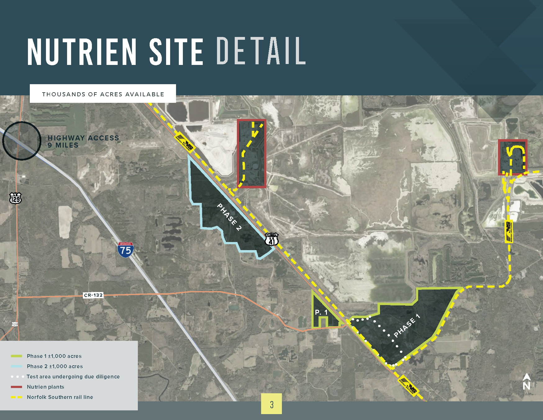
The Nutrien Crossroads Mega Site in White Springs, Florida, offers over 1,000 acres of prime industrial development land with exceptional access to highways, rail, ports, and a large regional workforce. Located just 9 miles from I-75 and 90 miles from Jacksonville’s port and airport, this site is ideal for large-scale industrial operations seeking connectivity, infrastructure, and growth opportunities in North Florida.
1,000 acres with exceptional access to highways, rail, ports, and a large regional workforce.
Property Details:
- Ownership: Nutrien, through White Springs Agricultural Chemicals Inc.
- Location: White Springs, Florida
- Type of Space: Vacant Land
- Size: 1,000+ acres immediately available (Phase 1: ±1,000 acres; Phase 2: ±1,000 acres)
- Zoning: Agricultural and Natural Resources Processing; zoning change required for industrial use. Re-zoning is an easy process and only requires annexation into the City of White Springs (90-day process) if municipal utilities are required.
Overview:
- Up to 1,000+ acres could be available now.
- Due diligence is available for 162 acres.
- Road access is along US Hwy 41. Spine roads are still needed.
- 75 interstate entrance is 9 miles away via CR-132.
- Norfolk Southern runs alongside property
Infrastructure:
- Electricity: 10+ MW available, 115 kV line nearby
- Natural Gas: Southern Natural Gas adjacent
- Water: Deep water wells and a municipal well nearby
- Wastewater: 8” force main running from White Springs
Access to Market:
I-75 entrance is 9 miles via CR-132
|
Type |
Available |
|
Strategic Intermodal System (SIS) |
I-75 via CR-132 |
|
SIS Railroads |
Norfolk Southern Class I mainline adjacent to the site |
|
SIS Airports |
Jacksonville International Airport (JIA) |
|
Seaports |
JAXPORT |
|
Non SIS State Highways |
US 41, US 129, SR 6, SR 25, SR 136, SR 143 |
|
General Aviation Airports |
Lake City Gateway Airport (KLCQ) – 39 miles |
Possible Target Industries: Warehousing & Distribution, Manufacturing, Agriculture
Logistics Park at I-75
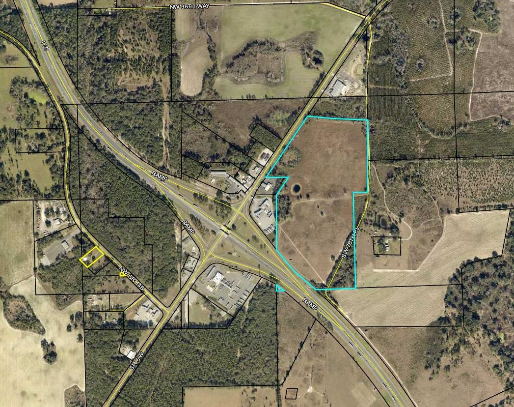
Prime location with I-75 and SR 6 frontage (approximately 800 feet from I-75 ramp). Within minutes of Florida/Georgia State line and I-10. State and local incentives may be available. This 58-acre parcel is suitable for warehousing, distribution, manufacturing and precision agriculture. Local governments are committed to assisting in the process of securing property and the maximization of all potential resources to include the establishment of an exceptional workforce.
This 58-acre site is perfectly positioned for a company that wants access and visibility to I-75.
Property Details:
- Ownership: Owned by the Hamilton County Development Authority (public)
- Address: I-75/SR 6
- City: Jennings; County: Hamilton; Zip: 32053
- Type of Space: Vacant Land
- Maximum Size: 58 acres. Nearby private parcels could be obtained for additional acreage.
- Zoning: Commercial, Highway Intensive
Overview:
- Logistical Park at I-75/SR 6 with 58 acres for development with I-75 Frontage.
- Property at I-75 and State Highway 6
- Water and sewer available
- Interstate visibility and access
Access to Market:
Immediate proximity to I-75 and SR 6
|
Type |
Available |
|
Strategic Intermodal System (SIS) |
I-75 |
|
SIS Railroads |
CSX |
|
SIS Airports |
Jacksonville International Airport (JIA) |
|
Seaports |
JAXPORT |
|
Non SIS State Highways |
US 41, US 129, SR 6, SR 25, SR 136, SR 143 |
|
General Aviation Airports |
Lake City Gateway Airport (KLCQ) – 39 miles |
Possible Target Industries: Warehousing & Distribution, Manufacturing, Agriculture
White Springs – Highway 41 Industrial Site
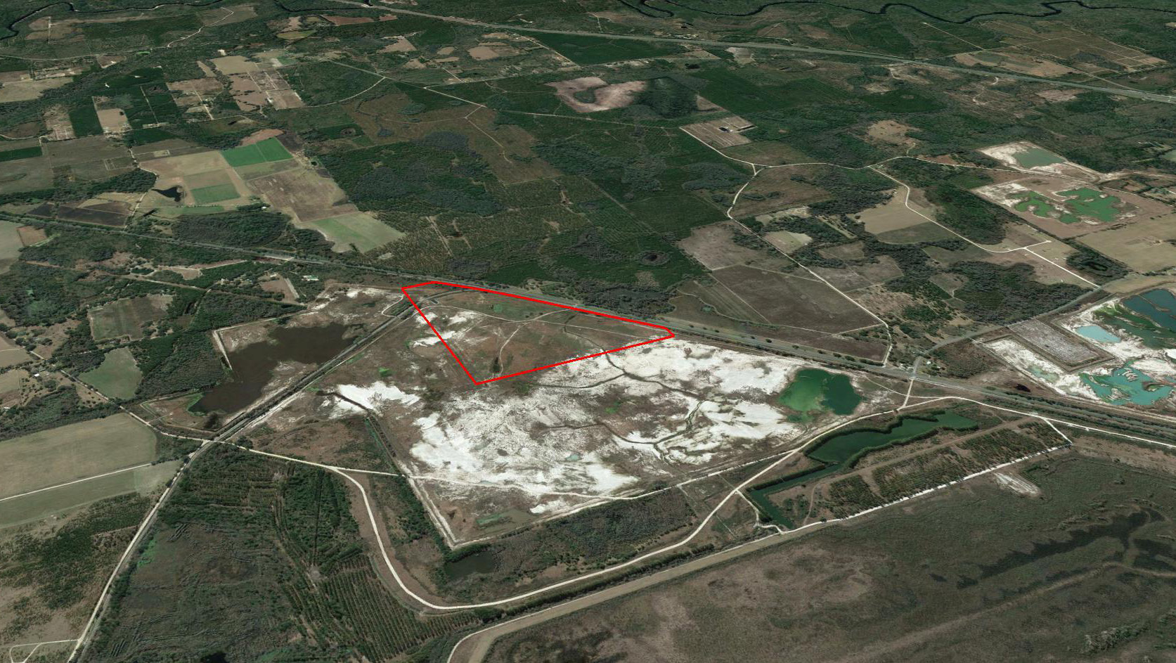
Publicly-owned 100-acre parcel located off U.S. Highway 41 with close proximity to I-10 and I-75 and features a Norfolk Sothern Railway line on site. The site suitable for warehousing, distribution, manufacturing and precision agriculture. Local governments are committed to assisting in the process of securing property and the maximization of all potential resources to include the establishment of an exceptional workforce.
This 100-acre site is located off U.S. Highway 41 with close proximity to I-10 and I-75.
Property Details:
- Ownership: Owned by the Hamilton County Board of County Commissioners (public)
- Coordinates: 30.391236, -82.825293
- City: White Springs; County: Hamilton
- Type of Space: Vacant Land
- Maximum Size: 90 acres.
- Existing Zoning: Agricultural (A-4). Must be rezoned to Industrial, Light and Warehousing (ILW)
Overview:
- Previous Land Use: Site was previously used as a phosphorus mine
- The site is located approximately 120 feet from U.S. Highway 41 (2-lane highway).
- Nearest N-S Interstate: I-75; 9.3 road miles from site
- Nearest E-W Interstate: I-10; 14.2 road miles from site
|
Type |
Available |
|
Strategic Intermodal System (SIS) |
I-75 (9.3 miles from site) |
|
Railroads |
A Norfolk Southern Railway rail line is on site. In order to access the rail line, a spur would need to be constructed off the main line and curve onto the property from the northwest corner of the site. |
|
Airports |
|
|
Seaports |
JAXPORT |
|
Non SIS State Highways |
US 41, US 129, SR 6, SR 25, SR 136, SR 143 |
|
General Aviation Airports |
Lake City Gateway Airport (KLCQ) – 39 miles |
Possible Target Industries: Warehousing & Distribution, Manufacturing, Agriculture
45-Acre Duke Energy Served Industrial Site
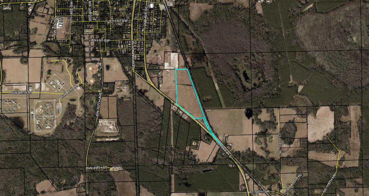
45-acre site approximately 3.5 miles from I-75 and 12.5 miles to I-10 with 1,082 feet of frontage on US 41; located in the Duke Energy territory with a substation to the rear of the site. The site offers the perfect combination of access, power and highway frontage in a low-cost location.
45-acre site approximately 3.5 miles from I-75 and 12.5 miles to I-10 with 1,082 feet of frontage on US 41; located in the Duke Energy territory with a substation to the rear of the site. The site offers the perfect combination of access, power and highway frontage in a low-cost location.
Property Details:
- Ownership: HCDA (public)
- Coordinates: 30.504466, -82.939646
- City: adjacent to the city limits of Jasper
- County: Hamilton, Florida
- Type of Space: Vacant Land
- Maximum Size: 45 acres
- Zoning: Commercial Highway Intensive
Overview:
- Previous Land Use: None, Greenfield
- This site has 1,082 feet of frontage on S. Highway 41 (2-lane highway).
- Nearest N-S Interstate: I-75; 3.5 road miles from site
- Nearest E-W Interstate: I-10; approximately 12.5 miles from the site
- Approximately 2,366 ft. of rail along the east border
- Adjacent to the city limits of Jasper and could be annexed quickly
|
Type |
Available |
|
Strategic Intermodal System (SIS) |
I-75 (3.5 miles from site) |
|
Railroads |
A Georgia Southern & Florida Railroad line is along the east border of approximately 2,366 feet, but currently no spur off the mainline. |
|
Airports |
|
|
Seaports |
JAXPORT |
|
Non SIS State Highways |
US 41, US 129, SR 6, SR 25, SR 136, SR 143 |
|
General Aviation Airports |
Lake City Gateway Airport (KLCQ) – 34 miles |
Possible Target Industries: Warehousing & Distribution, Manufacturing, Agriculture
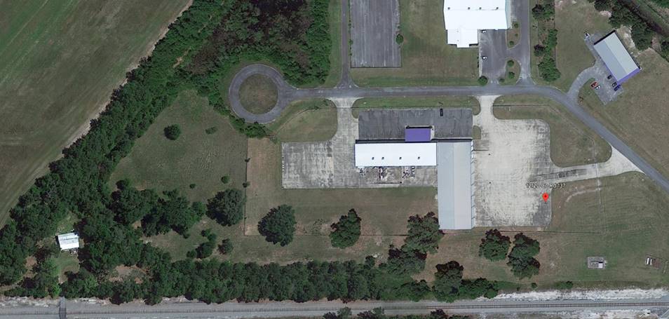
3.68 Acre Publicly-Owned CR 137 Industrial Park
3.68-acre site in the CR 137 industrial park with frontage on US 41 and located within 25 miles to the I-10/I-75 interchange. The site offers a ready industrial site with highway frontage in a low-cost location.
3.68-acre site in the CR 137 industrial park with frontage on US 41 and located within 25 miles to the I-10/I-75 interchange. The site offers a ready industrial site with highway frontage in a low-cost location.
Property Details:
- Ownership: HCDA (public)
- Address: 13122 SE County Road 137
- City: Jasper, Florida
- County: Hamilton, Florida
- Type of Space: Industrial Park
- Maximum Size: 3.68
- Zoning: Rural Development (RD) County
Overview:
- Previous Land Use: Industrial
- This site has frontage on S. Highway 41 (2-lane highway)
- Georgia Southern & Florida Railway runs across the U.S. Highway 41 frontage
- Approximately 23 miles to the I-75/I-10 interchange
|
Type |
Available |
|
Strategic Intermodal System (SIS) |
I-75/I-10 Interchange |
|
SIS Railroads |
A Georgia Southern & Florida Railroad line is along the border of the site but currently no spur off the mainline. |
|
Airports |
|
|
Seaports |
JAXPORT |
|
Non SIS State Highways |
US 41, US 129, SR 6, SR 25, SR 136, SR 143 |
|
General Aviation Airports |
Lake City Gateway Airport (KLCQ) – 34 miles |
Possible Target Industries: Warehousing & Distribution, Manufacturing, Agriculture

